India and China starts a Dams Race on the Brahmaputra River

Saturday, April 11, 2009

Worried that China might build a very big dam on the Brahmaputra River near its borders, India has recently approved two big dams of their own, "in principle", on the same river downstream in its state of Arunachal Pradesh. What is interesting, and disturbing at the same time, is that India is building these dams to pre-empt China by establishing a prior use claim.

A key member of India's Planning Council, Dr. Kirit Parikh, is reportedly pushing for this idea as "a broad strategic vision". I disagree with Dr. Parikh because China is not known for respecting riparian rights on international rivers. On the contrary, I think his words would only give more excuse for China to push ahead with their plans.


What follows is an editorial I wrote in 2004 in response to the news that India expressed concerns about Chinese plans then:

Let the Brahmaputra Flow
Tashi Tsering
Trin-Gyi-Pho-Nya: Tibet's Environment and Development Digest. January 12, 2004, Issue 4.

India finally expressed concern over Chinaís plans to divert the Brahmaputra River. In November 2003, several Indian news reports carried a story that the Indian state of Assamís Union Ministry of Water Resources asked their foreign affairs counterparts ìto seek factual detailsî about the project. Indiaís concerns became real after Chinaís official news agency, Xinhua, confirmed Chinaís intentions. According to Xinhua, preliminary studies of the water diversion project were conducted at the proposed construction site in mid-2003, followed by another round of feasibility studies in October. It would not be surprising if China denies having such plans, as did Tibet Autonomous Regionís Chairman, Xiang Ba Ping Cuo, at a press conference last August.

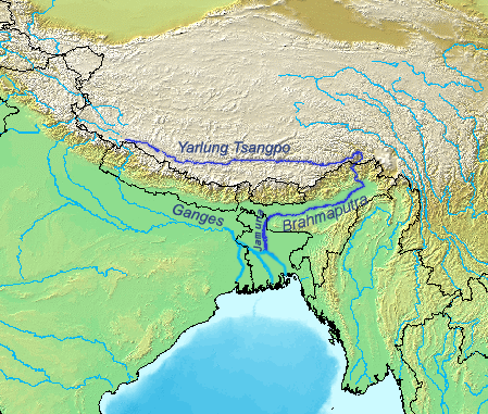
Construction of this mammoth multi-purpose project is tentatively scheduled to start in 2009. The main structures are planned in Tibetan areas of Pema Koe, near Indiaís northeastern border. The area is also known as the ìGreat Bendî of the Yarlung Tsangpo (Tibetan name for Brahmaputra) where the river takes a sharp U-turn to enter into India. At the Great Bend, the Tsangpo River descends over 3,000 meters in approximately 200 km, constituting one of the greatest hydropower potentials anywhere in the world. China hopes to build a hydroelectric plant there that would generate twice the electricity produced by the Three Gorges Dam, currently the worldís largest dam. Plans also include diverting the waters thousands of kilometers across the Tibetan Plateau to the ìthirstyî northwestern parts of China, into the provinces of Xinjiang and Gansu.

If undertaken, the project is bound to raise some serious transboundary issues. Claude Arpi, a Tibet-China-India analyst, called the project ìa declaration of warî by China. "When it comes to a transboundary question, where the boundary is not even agreed upon, it seems practically impossible to find a workable understanding," Arpi said. In addition to border disputes, the project would make India and Bangladesh dependent on China for release of water during the dry season, and for protection from floods during the wet season. Not to mention the adverse impacts on the millions of people living downstream when nutrient rich sediments and fish will be blocked by the dam. Arpi believes the most serious issue to be the fact that the Great Bend area is located in a highly earthquake prone area. "A huge reservoir and a few PNEs [Peaceful Nuclear Explosions, as proposed by Chinese scientists to make tunnels through the Himalayas for the project] could provoke new earthquakes even more devastating than in August 1950 when thousands died."

Such massive water control projects are clearly a state (central government) undertaking--without the economic and political support of the state, these projects cannot proceed. Unfortunately, and often ironically, national leaders prefer to marvel at their engineering accomplishments in controlling nature to serve economic development rather than addressing issues of transboundary and socio-environmental responsibilities. In fact, Chinaís plan to divert the Brahmaputra would impair India's own plan to link approximately thirty of its own rivers, a project that is bound to affect the downstream riparian state of Bangladesh.

Such international transboundary river development projects raise many important issues--from the comparative importance of national economic development to issues of social justice, from the primacy of territorial sovereignty to the merits of international cooperation. As important as these intractable topics of debate are, policy makers ought not to forget the real issue--the concern expressed by the affected people. After all, states exist to provide material and physical security to the people. The goal of development policies should be to benefit the people first, not powerful interest groups like corrupt bureaucracies and businesses.

While the Brahmaputra Diversion Plan will bring sizeable benefits to China in the form of construction jobs, electricity, and water for the "thirsty north," the price that the affected people and the environment must pay is clearly unacceptable. For the local Tibetans, the project is an imposition on their land and their birthright by the occupying Chinese government. The beneficiaries of the project are foreigners while "locals" are made to bear its price. If China is genuinely committed to human rights and sustainable development as it claims to be, then the Brahmaputra Diversion Plan should not be undertaken.
Read more on this article...

Uranium near Pangong Lake (སྤང་གོང་མཚོ༑) in Ladakh

Friday, April 10, 2009

I came across a news article from 2007 titled, "India finds uranium in icy Ladakh." It says that the uranium content (concentration) is the highest ever reported in India: as high as 5.36 percent compared to around 0.1 percent or less found in other sources of the country. If this is true, and if the reserves are significantly large, it is huge news (well, not any more) for India's nuclear program, especially for those who advocate India's nuclear independence and oppose the US-India nuclear deal. I actually travelled to that part of Ladakh, all the way to Spangmik Village of Pangong Lake, with a local freelance reporter, Tashi Morup . Here are some photos from that trip.


The fate of the people living in this corner of the world is uncertain. The farmers, pastoralists as well as nomads in this part of the region are concerned, nay, angry, at government plans to turn the region into a wildlife sanctuary. They are worried that government plans will impinge upon their traditional way of life. A wildlife sanctuary may restrict the number of livestock they can keep, limit their grazing area, ban collection wood, hunting and other such practices.


Read more on this article...

Photo of dam on Indus (Senge Tsangpo)

Friday, March 27, 2009


A friend just sent me a link which has a photo of "The Sengye Tsangpo Hydropower Station." Upon comparing the photo with the dam on Ngari I found on Google Earth last week, it's clear that these are the same dam. According to the text on the photo, the Sengye Tsangpo Hydropower Station has an installed capacity of 6,400 Kilowatts and is now operational. Read more on this article...

The Qinghai Lake eco-environmental protection and comprehensive management project

Monday, March 23, 2009


Map source: QInghai Province website

In May 2008, the government of Qinghai Province launched the 10-year project to restore the ecological integrity of Lake Kokonor (called Tso Ngon by Tibetans, མཚོ་སྔོན་) region. Key environmental protection objectives include protection of wildlife biodiversity, wetlands and the grasslands of the region, which are believed to be threatened by global warming, desertification, human encroachment, over-grazing by yaks and sheep, and also by rodents and pests.

The project area is 30,000 square kilometers in size and comes with a promissory central government funding of $227 million. This project follows the example of a larger conservation project in the same province, the Three Rivers Headwaters Nature Reserve.

Measures to achieve project goals include planting trees and shrubs, controlling rodents and insect pests, and curtailing grazing on grasslands by fencing and "ecological migration" of nomadic herders living in the region.

Plantation of trees and shrubs sounds fine but I wonder what species of plants are being used and if these are sustainable considering local ecology.

Government measures to control rodents on the Tibetan Plateau have been controversial. The mainstream assumption of the government, supported by many local people, is that rodents, which have been found to be rapidly increasing in population, are causing grassland degradation and are competing for forage with livestock. The three main rodent species are plateau pikas (Ochotona curzoniae), voles (Microtus brandti), and zokors (Myospalax baileyi). The government has undertaken many poisoning campaigns to exterminate these little animals in the last few decades. The rodenticides not only killed target animals but also many other species of plants and animals.

In 1999, an important study was published in the journal of Animal Conservation by Andrew Smith and Mark Foggin that shattered the logic of this poisoning campaign. Smith and Foggin argued that the plateau pikas are a "keystone species" which provide essential ecosystem functions to the Tibetan Plateau. The animals are a major food source for wolves, brown bears and most of the large predatory birds of the plateau. The scientists also found that many nesting bird species use pika burrows as shelters for breeding. The increasing number of rodents on the Tibetan Plateau are a symptom, not a cause of environmental degradation.

Another important study by a team of scientists found that grazing is not the cause of rangeland degradation on the Tibetan Plateau but climate warming. Research experiments found that simulated grazing actually dampens loss of plant species diversity caused by climate warming. The team of scientists have also published an argument in the journal Ecological Applications.

There are a ton of studies that have looked at the implications of fencing of Tibetan rangelands. My advisor Tsering Shakya once told me that the academic/scientific consensus on the topic clearly show that the policy has been a disastrous failure. I have read reports from wildlife scientists such as the one here by noted biologist George Schaller who argue that fencing causes problems for many endangered animals such as the Tibetan Antelope (Pantholops hodgsonii) and the Tibetan gazelle (Procapra przewalskii). These animals and the local people prefer their grasslands to be open without fences. This study, for example, indicates fencing actually exacerbating overgrazing and causing health problems among Tibetan pastoralist communities.

I think the most important perspective on this topic would be those of the nomads who are directly affected by the projects. My colleagues at TEAM will be interviewing some of these people. If anyone else have any information or insights to share, please let me know.

Before I end this blog, I want to mention about two earlier posts relating to the project area. One was about a government edict which admits there is a problem of illegal gold mining in the region. We also translated a news story about skirmish between nomads and fisherman near the lake.
Read more on this article...

Accuracy of Three Rivers Headwaters Nature Reserve Map

Sunday, March 22, 2009

A friend just forwarded a link to Chinese language maps of Three Rivers Headwaters (San Jiang Yuan) Nature Reserve and "Qinghai Lake eco-environmental protection and comprehensive management project". This link is from the official website of Qinghai Province. Here is its SNNR map.


I am pleased to say that the map of SNNR confirms the accuracy of the SNNR map that was released on this blog last month (February 2009). Of course, our map provides more details, including demarcation of zoning systems within the subareas of the reserve.

I will post a separate blog about the map of Qinghai Lake eco-environmental protection and comprehensive management project" since this is the first time I am writing about it.
Read more on this article...

Pakistan shocked at Chinese dam on Indus River

Thursday, March 19, 2009

I have heard word-of-mouth stories of a Chinese dam on the Tibetan headwaters of Indus River (Senge Khabab, སེང་གེ་ཁ་འབབ་) but never saw anything published about it. A news story from Pakistan confirmed the rumour today. I tried to locate the spot where the dam could be using Tibetan Himalayan Digital Library's handy mapping tool. Unfortunately the satellite imagery is not clear on close-up and the mapping system won't show rivers. So I drew a VERY rough blue line (took me few seconds on PhotoShop) on the map to show Indus headwaters. The dam is located near Ngari (མངའ་རིས་, called "Ali" in Chinese) township, circled in black, in Gar (སྒར་) county in Western Tibet.


I then checked on Google Earth, and guess what, the dam is clearly visible there. See a screen shot of GE image below. The dam is situated at 32 degrees and 31 minutes North latitude, and 80 degrees and 10 minutes East longitude. It is built on a tributary of Indus River, which flows from East to West joining the main (Indus) river at 32 degrees and 31 minutes North latitude, and 79 degrees and 42 minutes East longitude. The "city" on the left of the image is Ngari township.

Read more on this article...

China and the freedom of information

Tibet has been shut off from the rest of the world for about a month now. Even Tibetan language websites and blogs have been shut down "for maintenance". So the rest of the world is essentially dependent on Chinese state run news agencies such as Xinhua and People's Daily for news. The government can churn whatever information they want as "factual news" now. Independent (and all foreign) journalists have no access to Tibet. Interestingly, Chinese state media has reported several stories linking Tibetans and bombs in the last two weeks. Although these reports haven't produced any evidence or photographs, foreign media is quick to put their own spin to the stories.

How about environmental news from the rest of China? Surely, there is more freedom there. However, censorship is also widespread. Here is an interesting story from China Digital Times:


Guangdong Nansha integrated oil refinery and petrochemical project is a major inititiative, involving Kuwait National Oil Company and Guangdong Province. The project’s potential impact on the environment became a concern of not only the residents of Guangzhou, but also neighboring Hong Kong. On March 4, 2009, Hong Kong legislator Yu Ruohui raised this question, and the Director of the Environmental Protection Department in Hong Kong replied, saying, “As far as we understand, the impact assessment of the proposed project has yet to be approved.”

However, in the last few days, an internal notice from Internet supervision departments was sent to all major Chinese news websites, translated by CDT’s Japhet Weeks.

“Environmental impact report for the Guangdong Nansha integrated oil refinery and petrochemical project”: All internet sites are prohibited from reproducing, commenting on, or discussing anything relating to the content of this report. Nor should it be discussed on blogs. Furthermore, blogs should set up keyword filtering to make sure the topic isn’t discussed. All websites are requested to strictly implement these rules.

《广东南沙炼油化工一体化项目环境影响报告书》将于近日公示,公示期间,各网站对有关内容不转载、不报道、不评论,论坛、博客不讨论并设置关键词过滤。请各网站务必严格执行。

Read more on this article...

Grasslands of Bathang County unsafe for livestock due to mining

Tuesday, March 10, 2009

Bathang county (Tibetan: འབའ་ཐང་; Chinese: 巴塘县) gets its name from Tibetan, meaning the vast grassland where one can hear sheep everywhere. "Ba" refers to the sound made by sheep, and "Thang" means plains or grasslands (as in "Tsa-Thang"). However, Washington Post has published a story today that says that the grasslands are not safe for the sheep anymore due to gold and copper mining in the region. Here are two quotes from the article:

Their sheep die when they drink tainted water flowing from the mine, or lick crushed ore left on the hillside, villagers say. Now there are reports that the mine will open another cave this year in the upper grassland above Dorje's home. "We are trying to think of every possible way to stop this. If we have to, we will carry stones and wood sticks to block the entrance as soon as [the miners] begin to dig again," he said.

"Last year, eight of my yaks died. They just fell down, foaming at the mouth," said Gompo Dondrup, a nomad and farmer in Bathang county in western Sichuan province, whose family has lost more than 60 percent of its herd. "At first we didn't know why. Later, the veterinarians told us it was because of the mine. We protested, but the mine continues to operate. They said they gave compensation to the government, but the government never gave us any."

Read the full Washington Post article here .
Read more on this article...

A delightful surprise to the people of Phagri

Monday, March 9, 2009

People of Phagri (ཕག་རི་), near Shigatse (གཞིས་ཀ་རྩེ་), have some wonderful visitors this year. Xinhua reports that a flock of Black-necked Cranes have chosen Phagri, instead of their usual spot in Nyalam (གཉའ་ལམ་), as their resting site this winter.

[Photo: Xinhua]

The Black-necked Cranes, also known as Tibetan Crane (scientific name: Grus nigricollis), is well known among the Tibetans. Trung Trung Kenag (ཁྲུང་ཁྲུང་སྐེ་ནག་), more popularly known as Trung Trung Karmo (ཁྲུང་ཁྲུང་དཀར་མོ་ / "White Crane"), is a bird immortalized by what is believed to be the final and the most popular poem composed by the legendary sixth Dalai Lama, Tsangyang Gyatso (ཚངས་དབྱངས་རྒྱ་མཚོ). A story goes that the poet Dalai Lama was sitting on a mountain top, looking for inspiration. Just then he saw a White Crane flying in the sky. He spontaneously broke into a song: "Oh White Crane, lend me your wings. I shall not fly far. From Lithang, I shall return."

The 6th Dalai Lama's last poem is believed to contain signs of his next life as the 7th Dalai Lama was born in Lithang. Here is a video of a man and a girl singing the song:


The Black-necked Crane is also popular among naturalists and environmentalists. According to the International Crane Foundation, Black-necked Cranes were the last species of crane discovered and described by ornithologists (1876). With a declining trend in its total population, which is only about 5,000-6000, the endangered Black-necked Crane is listed as "Vulnerable" in the IUCN Red List of endangered animals. The Black-necked grows to a height of about 4 feet (115cm) with an amazing wing span of nearly 8 feet (235 cm) and weighs about 12 pounds (5.5 kg).

Climate warming is known to drive animals and plants towards higher altitudes and latitudes (comparatively cooler regions) as temperature becomes too hot in their natural habitats. Migratory birds are worse off as these animals must travel long distances, covering different regions with very different environmental conditions. Related to the topic, BBC has produced a four-part documentary series called "Animal Migration in a Climate of Change" . As the Himalayas get warmer and the glaciers melt, the lakes and marshlands in areas around Phagri have become larger, and the surrounding meadows and shrubs have become greener. All these changes have made the area into an ideal winter hibernating site for the Black-necked Cranes, according to the Xinhua article.
Read more on this article...

Qinghai edict on the ban on mining of gold powder

Saturday, March 7, 2009

While going through Tibetan language blogs, I came across a notice issued by the Qinghai Provincial Government on the ban on mining of gold powder. The blog was posted on January 30, 2009. I don't know when the edict was issued, nor have I seen the text of the original Chinese source. Some readers may still find the document of interest, so here are screen shots of the original document (only) along with an English translation of the text. This document proves that the government acknowledges there are mining problems in Qinghai, specifically in Drito and Zato counties of the Three Rivers Headwaters Nature Reserve. It is also interesting to note that mining (or collecting) gold powder is not banned completely. The ban is mainly for miners from other provinces.


Edict on the Ban on Mining of Gold Powder issued by the Qinghai Provincial Government

The ecological system of the Tibetan plateau is so fragile that it cannot be restored after it has been damaged. Therefore, in order to protect the natural environment around the [headwaters] of the three rivers and maintain sustainable development in the three river basins, the provincial Government of Qinghai has issued [the following] edict.

One
All the mining areas in the Dokha and Kyikha valleys of Padma county and Dzatod in the Khridu county run by prospectors from outside provinces should be closed immediately.

Two
The Forestry Department, Environmental Protection Bureau, Department of Animal Husbandry and Legal Department in different levels in the region must launch a campaign on the protection of the natural resources and promote awareness of environmental protection among the local people.

Three
All the local governments [are responsible for posting billboards about] environment protection along the highways.

Four
Town governments are responsible for preventing its people from digging gold powder and for providing advice and helping them to establish certain environmental protection regulations in accordance with their cultural tradition.

Five
Different levels of government in the region should actively engage with the protection task and not only lead the local people toward the path of economic development but also encourage them to enhance their living standard through greater agricultural and pastoral production as well as other small industries.

Six
Mining areas in Dokha and Kyikha of Padma County and Dzatod in Khritod county should be managed according to the environmental protection law designated by the regional government.

Seven
The legal branch offices responsible for natural resource management at different levels of government in the region must impose rules on the prevention of digging natural resources and those who violate the law should be punished according to the Management Regulation of Natural Resources of Qinghai Province and other regulations issued by the government.
Read more on this article...

Dams on Tibetan areas of Brahmaputra and Mekong

Thursday, March 5, 2009

[photo: wikipedia]

1. Brahmaputra (Yarlung Tsangpo), one of the last two free-flowing, undammed major rivers in Tibet, AND China, is also being dammed. Salween is the other major river that environmentalists tried to save from dam projects but to no avail. A China Daily story yesterday acknowledged that the "Zangmu Water Power Station" is on the main stream of the middle reaches of Brahmaputra, at dZam (རྫམ་) township. Sources tell me that there are five dams planned in this section of the river, and construction has been going on since 2006. This means there is no undammed major river in China and Tibet. The installed capacity of 'Zangmu Water Power Station' will be 510 MW (85 MW x 6 turbines). The project is located in Lhokha (Shannan) Prefecture of Tibet Autonomous Region, about 140 km southeast from Lhasa, between Zangs-Ri (Sangri) and rGya-Tsha (Jiacha) counties. Construction work on the first dam is likely to start soon. Huaneng, China's top power company, is backing the financing of the project and, Gezhouba, one of China's biggest dam construction companies, will build the project. This news should be particularly alarming for people living in downstream countries of India and Bangladesh. China is likely to approve more dam projects on the Brahmaputra this year.

2. In March 2007, Tibet Environment Bureau approved another five dams on the headwaters of Mekong (Zachu) in Chamdo Prefecture. China has already built several dams on the Mekong in Yunnan Province that have impacted downsteam ecology and livelihoods. The Mekong River flows into Thailand, Burma, Cambodia, Laos and Vietnam. This time, however, authorities have released the Environmental Impact Assessment report of the Zachu dams. As far as I know, this is the first time China has released EIA of dam projects on transboundary rivers.

The total installed capacity of the five dams will be 510 MW. The names of five dams are (all in Chinese): Dhongzhong, Guoduo, Xiangda, Ruxi and Linchang. These dams are located close to each other, around 31 degree North latitude and 97 degree East longitude. This is a low population rural area at an altitude about 4,335 meters (14,225 feet). Dhongzhong and Guoduo are located near Tsher-dBad (ཚེར་དབད་ / Cerwai' in Pinyin) township, Xiangda is located near Re-Thong (རེ་ཐོང་ / Retong in Pinyin) township. Ruxi and Linchang are located near Ru-bZhi (རུ་བཞི་ / Ruxi in Pinyin) township.
Read more on this article...

Himalaya, the "Mountains of Concrete": a review

Sunday, March 1, 2009


Mountains of Concrete: Dam Building in the Himalayas. International Rivers. 2008.  

Mountains of Concrete by Shripad Dharmadhikary is a fine new report that looks at dam building trends in the Himalayan regions of Pakistan, India, Nepal and Bhutan. To the best of my knowledge, this is the first critical report of its scope and focus, definitely an important contribution to the debates over dam building issues in the region. However, the exclusion of Tibetan Himalayan rivers renders this otherwise comprehensive regional study still incomplete, especially since the Tibetan sections of these rivers are the critical headwaters. The report explains that the omission is due to lack of information and resources. This is personally very disappointing as I believe the information and resources are out there, if only the author and the publisher had dug more deeply to find them.

The report, however, does dedicate a full-page story (Box #4, page 20): “China ‘Goes Out’ to Build Himalayan Dams.” It provides a brief overview of Chinese dam-building expertise and the politico-economic context under which it is ‘going out’ to build “hundreds of dams” in South Asia, Africa, South America, Central Asia and other regions of the world. In South Asia, the report says that “Chinese companies have built or are building at least 13 projects in Nepal and nine in Pakistan.” There is a quick mention of Chinese plans to build a dam on Yarlung Tsangpo (Brahmaputra), an idea that is alarming to the downstream countries of India and Bangladesh. Since Tibet is the headwaters to many of the major rivers discussed in the report and there are innumerable dams built and planned on the Tibetan Plateau, we can only hope that International Rivers will take up this incomplete project and produce a sequel report about Chinese dam projects in Tibet. Readers interested in getting a glimpse of Chinese dam-building trends on the Tibetan Plateau are encouraged to read this paper.

That said, I want to share some of the many excellent points that are discussed in the report and point out certain important topics that could have been been included. This 48-page report is neatly divided into different topical sections. The first half of the report presents an informative country-by-country discussion of dam-building trends, funding issues and the key players. I found the discussions about Nepal and Bhutan most informative since not much is known about dam issues in these two countries. I did not realize until today, and it is not very surprising as one comes to think of it, that hydropower development represents the biggest source of income for Nepal and Bhutan. According to the report, about half of Bhutan’s national income comes from hydropower development. Bhutan has an installed capacity of 1,448 MW and plans to increase it to 15,693 MW. Nepal is more ambitious, it plans to install a total capacity of 26,324 MW from its current installed capacity of 545 MW. India’s goal is 93,615 MW from 15,208 MW. And for Pakistan, it is 33,769 MW from the existing capacity of 6,385 MW.

The drivers of hydropower in Pakistan and India are different. Pakistan wants big dams for irrigation and agriculture. In India, there is much higher demand for electricity and r
egional development. Needless to mention, the Indian power companies' rush to earn huge profits is also a major factor. A look at sources of funds is also interesting. The involvement of international financial institutions (IFI) such as the World Bank and Asian Development Bank are common throughout the region. For Bhutan, the main source of funds is India. Nepal has a more diverse source of income, including domestic sources, private-public partnerships, India as well as China. China is also an important funder for Pakistan. Other sources of funds for Pakistan include internal government sources, foreign private banks and income from sale of power. India’s main funders are its government, domestic banks and financial institutions.

Funding is the biggest challenge to the developers in this mostly rural region. Even if all the available funds are added up, the report estimates that 40% of the funds still remain unsecured. Power sector reforms to raise necessary funds are essentially geared towards privatization. The availability of funding is largely dependent on the ability of the power sector to recover investments, which to me is doubtful because of factors such as climate change, poor performance track record of big dams in general, and the South Asian context of corruption and unstable local/regional politics. However, I imagine the greatest funding problem right now is the global economic crisis as energy demands and investments in many parts of the world are declining. 


The main argument of the first section is the lack of morality in the economics of big dams in the region. Who are the ultimate winners and who are the losers? While the report does not question the role of state in hydropower development in the tradition of political ecology or post-structuralist critics, it raises issues of equity and the plight of the poor and affected people. The prospective winners are the banks and bureaucracies whose interests are directly proportional to the size of investment and prospective profits. The losers are the affected people, many of which are the many unique indigenous peoples (Adivasis, jan jatis), and the environment. In fact, the report is ultimately a warning that the Himalayas themselves and the whole region would face grave consequences if its people and decision-makers fail to act as its custodians.

The second half of the Concrete Mountains report is dedicated to the social and environmental issues. There are a lot of topics covered in this section (downstream impacts, loss of resource base, direct submergence, cultural impacts, ecological impacts, seismicity and sedimentation, climate change, etc.) that could have benefited from focus in terms of a specific target audience that ideally is also relevant to the debate. This section also provides a brief discussion on the response from affected people. I have always been most impressed with the various anti-dam movements in India. The national policy debates raised by the Narmada Bachao Andolan, and the mobilization of affected people’s resistance not only on the Narmada campaign but also other projects such as Teesta in the Northeast are inspiring examples for other dam-affected people. [TEAM has translated the Citizens’ Guide to World Commission on Dams, an activist organizational tool kit for people affected by dams, into Tibetan. We have sent a few copies to Teesta activists and are happy to send more copies for free to anyone who places an order.]

I am pleased that the report rightly situates the debate within the context of climate change. I believe climate change provides an important, pertinent and powerful critique of dam development in the region. If the glaciers and snows that feed the Himalayas are disappearing, why build such large, expensive and inhumane concrete structures? Some experts argue that big dams will be useful for storage purposes if climate change results in changes to water flow patterns. We can use the dams to store water when there is excess and release when supply is scarce. This report rejects this argument. Current dam projects, including those in the ‘pipeline,’ will not be able to deliver the designed benefits since flows are expected to decline significantly in the long run. Big dams in the Himalayas also increase other risks that are more common to the region such as glacial lake outburst floods (GLOFs) and seismicity.

Another important point that I was delightfully surprised to see emphasized in this report is the issue of cumulative impact of these dams. What will be the long term added incremental impact of all these dams to the region’s environment and economy? No one has the answer to this question. Perhaps we will never know the answer to this question beforehand but this is an important conceptual question for people and policy makers concerned about the future of the region’s cultural and ecological heritage. A step in the right direction toward understanding cumulative impact is to include cumulative impact assessments in project environmental impact assessment measures.

While such important points are raised in the report, there is no discussion of certain other relevant and important concepts such as minimum in-stream flows, ecosystem services (of headwaters and free flowing river, for example), and human rights impact assessment. I think all of these concepts should be made relevant to any discussion of dam project planning to minimize environmental and social costs. It would have been very fitting for the report to include these concepts as a part of its recommendations to governments and funders, a section that is also missing in the report. I would have either expanded the final one-page discussion on “Alternative Approaches” or included a set of recommendations for different target audiences, such as governments, IFIs, affected local people groups such as the Affected Citizens of Teesta.

It is unfair to expect a report to cover all relevant topics under the sun. For what it has set out to do, I think the report has achieved its purpose barring the unfortunate exclusion of Tibet and China. I wish to congratulate Shripad Sharmadhikary and the International Rivers for releasing this informative critical report.
Read more on this article...

Settlement vs. Resettlement

Tuesday, February 24, 2009

Some people responded to my last blog post with more information that I want to share with readers.

1. There are many kinds of housing projects that are being built for herders and farmers on the Tibetan Plateau. So unless someone cross-checks the numbers on the ground, it is difficult to figure out exactly how many herders have been resettled.

2. A couple of friends (Thanks again!) brought to my attention that the Reuters article discussed in my previous blog post talks about 'settlement' (ding ju) of herders, which is different from 'resettlement' (yi min) of herders. Settlement likely means simply building permanent houses at the winter pastures where villagers live -- which is not in any way as serious as "resettlement" or "ecological migration" where herders are removed to new areas as in the case of the Three Rivers Headwaters Nature Reserve.

4. Speaking of 'ecological migration,' What happens to all the yaks when the nomads are forced to resettle? It seems like many sell the animals as they are suppose to do, while others leave their yaks with relatives for keeps. I don't have any credible or interesting story about the fate of these animals. Please share any information you may have on this issue.

3. Some housing projects are simply replacing traditional mud houses with houses made of bricks. This project is more prevalent in Tibet Autonomous Region, where, in total, 860,000 farmers and herders from 170,000 families have moved into the new houses by the end of 2008. According to this Xinhua article , "another 312,000 farmers and herders from 57,800 families moved from shanty homes into new solid brick houses in Tibet [Autonomous Region] this year under a government-subsidized housing project aimed at improving living conditions."

As much as I think this is a tragedy in terms of losing traditional architecture (its cheaper, locally more suitable, environmentally more sustainable, better insulation for Tibet's cold winter, aesthetically more beautiful, etc, etc.), these brick houses are popular among Tibetans. I have seen this trend among Tibetan Buddhist farmers of Ladakh and in Spiti Valley in India. While many of these farmers tend to prefer houses made of bricks with corrugated tin roof as modern and reject their traditional mud houses as pre-modern, many local leaders are clearly concerned about implication of these changes.


[Traditional Tibetan architecture in the Western Himalayas. Photo: Tashi Tsering]
Read more on this article...

Snuffing out the nomads?

Monday, February 23, 2009

A friend brought this Reuters article to my attention. He was baffled by the sheer number of Tibetan herders that the article says will be relocated. According to the article, there are 530,000 nomads in Western Sichuan Province, out of which 470,000 herders will be resettled in the name of environmental protection. If these numbers are true, that's the last of the nomads in Sichuan. He said this is effectively "a kind of nomad genocide.” Although I never thought of this as such, I was pleased to see that at least someone was paying attention to this issue.

As evident from my earlier postings, I have been very concerned about the many large scale ecological resettlement projects going on in Tibet. To me, this is a far more serious issue than the high profile topics such as Hillary Clinton’s China visit or the arrest of monk protestors. Precisely because the resettlement project is a low profile, politically-correct sounding policy in the context of environmental protection, I think it is one of the most far-sighted strategies of the Chinese state to deal with several serious problems on the Tibetan Plateau at the same time. As the saying goes, "Kill many birds with one stone".


China has designated many areas on the Tibetan Plateau for different environmental protection goals. Local people living in these regions are usually forced to sell their yaks and then resettled somewhere. I haven’t dug into the numbers yet, but it is clear from Xinhua and other official reports that several hundred thousand people, mostly nomads and pastoralists, are being resettled from these “protected” areas. This Science magazine article, for example, talks about government plans for the “ecological migration” of nomadic herders living around Kokonor Lake (Tso Ngon) to restore the region’s “degraded” ecology. The power of scientific and environmental discourse makes these projects sound like noble endeavors. How could anyone oppose protection of wetlands, lakes, and endangered animal species?

There are other benefits of resettling Tibetan herders. The government wants to provide access to education, health, postal system and other development schemes in every corner of the country. Promotion of economic development, especially in politically volatile regions, is an important technique for promoting state legitimacy. The Tibetan herders have been a major problem to state policy makers in this regard. Statistics reflect these people poorly on both economic and human development scales, for which the government receives a lot of criticism, but it is difficult for the government to provide them access to development due to their nomadic and subsistence lifestyle. So settling them in housing colonies is one obvious way of dealing with this problem.

The Tibetan nomadic lifestyle is the heart of the traditional Tibetan economy, which is reliant on herding of yaks, goats and sheep. The nomadic lifestyle represents the symbolic spirit of Tibet to many people. Romantic notions of Tibetan nomadic life are popular not only among Tibetans and Western sympathizers but also among Chinese people. The government could not have settled the nomads by calling their lifestyle “backward” or “primitive”, as it was done in the past. The perfect excuse to do this, thus, is within the context of environmental protection. Rallying support for environmental protection on the Tibetan Plateau is easy. Tibet is known for its “biodiversity hotspots”, pristine lakes, old growth forests, “fragile grasslands”, and for being “China’s Water Tower.” And resettling people from nature reserve parks is not a new idea but a well tested strategy. States around the world have declared many areas inhabited by troublesome indigenous peoples as nature reserves in order to control and assimilate them into the political economy.

The real issue is not about a clash between romantic notions of the Tibetan nomadic lifestyle and state development. It is about choices, whether the herders have a say in the policies that shape their lives. Do the herders have a choice whether to resettle or not? The issue is also about scientific management. Is it scientifically appropriate to remove herders and halt grazing on the Tibetan Plateau? Julia Klein, a scientist who specializes in climate change impact on grasslands of the Tibetan Plateau, says that the ecology of the region “is a system that has evolved with grazing; the removal of grazing from the system could have profound ecological consequences.”

Going back to the topic of “nomad genocide,” I wonder if anyone has actually done some research on the numbers. I can only hope the figures quoted in the Reuters article are inaccurate or exaggerated. I wonder how many people have really been resettled so far, and how many more are yet to be resettled? If any of you readers have any information, please share. Thanks for reading this, and spread the word!
Read more on this article...
5.8 billion US$ to displace more Tibetans

Monday, February 16, 2009


I re-subscribed to TIN updates yesterday and this morning I saw their latest news digest in my inbox. The updates were full of grim news: more protests and arrests on the Tibetan Plateau. Yesterday I learned that one of my best friends is unable to enter Kham (Eastern Tibet) from Chengdu. He may have to return to North America and postpone his work related to hospital and school building projects in the region. Authorities have closed off (many parts of) Eastern Tibet to ensure "stability" apparently because "March 10" is around the corner.

There was a different news piece that struck me. It directly relates to the questions I raised in an earlier post. The government has allotted 5.8 billion US$ to displace even more Tibetans in the name of environmental protection. How I wish people paid more attention and probed deeper into these issues. Here's the brief update from TIN:

"Tibetan nomads, farmers may be losers in China's ecology protection plan (Xinhua) More Tibetans are set to be displaced, losing their ancestral land, homes and way of life, as China spends 20 billion yuan (UK4.1 bn; $US5.8 bn; EUR4.5) during its eleventh Five-Year Plan period (2006-2010) to build a State Ecological Safe Shelter Zone on the Tibetan Plateau, reported state-run Xinhua. "Problems such as grassland degradation, land desertification, glacier meltdown, soil erosion etc. are affecting the whole ecological environment in China" because of the deterioration of the environment on the plateau, it said. Three shelter zones will be constructed from 2008 to 2030. The report said measures will include returning grazing land to pastures, controlling rodent and pest damage, standardising construction of five regional nature reserves and rural biogas construction."

On a different note, the High Peaks Pure Earth blog has an interesting story about Angry Tibetan Netizens over continued use animal fur by Tibetans on their ceremonial dresses.

Read more on this article...

Tibetan Language Maps of Three Rivers Headwaters region

Saturday, February 14, 2009


A kind supporter of Tibetan Plateau donated some photos of Tibetan maps showing Yushu, Nangchen, Drito, Zato, Chumarleb and other areas of SNNR. The maps were published by Tibet Information Network, a reproduction of "བོད་རང་སྐྱོངས་སྲིད་འཛིན་ས་ཁུལ་གྱི་ས་བཀྲ་", a set of nine maps made by the Chinese authorities in 1981. Since Tibetan language maps are quite rare, I hope these will be of interest to many people, especially Tibetan readers.


Read more on this article...

Update on SNNR map and related China Beat Blog article

Friday, February 13, 2009


Update: SNNR subarea #7 Zhaling-Eling Hu (མཚོ་སྐྱ་རིང་སྔོ་རིང་)་extends into Dulan County, Haixi Mongolian & Tibetan Autonomous Prefecture. This news wasn't too surprising as mentioned in SNNR Map Description that SNNR subarea boundaries cross administrative borders. Map in previous blog entry has been updated. We are working on further improvements.

An excellent article related to SNNR on The China Beat blog by Ken Pomeranz . Here's an excerpt focusing on Tibet's water:

[The] state has chosen a massive three-pronged effort to move water from South to North China – by far the biggest construction project in history, if it is completed. Part of the Eastern section began operating this year, and the Central section is also underway (though the December 31Wall Street Journal reported a delay due to environmental concerns). The big story in the long run, however is the Western line [in SNNR], which will tap the enormous water resources of China’s far Southwest – Tibet alone has over 30 percent of China’s fresh water supply, most of it coming from the annual run-off of some water from Himalayan glaciers. (This is an aspect of the Tibet question one rarely hears about, but rest assured that all the engineers in China’s leadership, including Hu Jintao and Wen Jiabao, are very much aware of it. Tibetans, meanwhile, not only see a precious resource going elsewhere when their water is tapped: they regard many of the lakes and rivers to be dammed as sacred.) The engineering challenges in this mountainous region are enormous, but so are the potential rewards, both in water supply and in hydropower – the electricity water can generate is directly proportional to how far it falls into the turbines, and the Yangzi, for instance, completes 90 percent of its drop to the sea before it even enters China proper. The risks, as our two stories make clear, are social and political as well as environmental…

Call the two news stories the “double glacier shock.” On December 9, Asia Times Online reported that China was planning to go ahead with a major hydroelectric dam and water diversion scheme on the great bend of the Yarlong Tsangpo River in Tibet. The hydro project is planned to generate 40,000 megawatts – almost twice as much as Three Gorges. But the water which this dam would impound and turn northwards currently flows south into Assam to form the Brahmaputra, which in turn joins the Ganges to form the world’s largest river delta, supplying much of the water to a basin with over 300 million inhabitants. While South Asians have worried for some time that China might divert this river, the Chinese government had denied any such intentions, reportedly doing so again when Hu Jintao visited New Delhi in 2006. But when Indian Prime Minister Singh raised the issue again during his January, 2008 visit to Beijing, the tone had changed, with Wen Jiabao supposedly replying that water scarcity is a threat to the “very survival of the Chinese nation,” and providing no assurances. And so it is – not only for China, but for its neighbors. Most of Asia’s major rivers – the Yellow, the Yangzi, the Mekong, Salween, Irrawaddy, Brahmaputra, Ganges, Sutlej, and Indus – draw on the glaciers of the Himalayas, and all of these except the Ganges have their source on the Chinese side of the border. Forty-seven percent of the world’s people, from Karachi to Tianjin, draw on those rivers.

Read more on this article...

Mapping Three Rivers Headwaters Nature Reserve (Updated)

Thursday, February 12, 2009


In May 2000, China declared the establishment of its largest nature reserve on the Tibetan Plateau: the San Jiang Yuan (Three Rivers Headwaters) National Nature Reserve (SNNR). Since then, China’s plans to protect the headwaters of the Yangtze (Drichu), Yellow (Machu) and Mekong (Zachu) rivers have received a lot of media attention. This recent BBC story, for example, highlights the relocation of '100,000 nomadic Tibetans.' However, there is very little information about the specifics of the plan in all of the published sources that I have come across. There isn't a single definitive map of SNNR. So I collaborated with some colleagues, who wish to remain anonymous, and prepared a new map of SNNR area using information compiled over the last few months. I am pleased to release the map here.


[Click on the image to view/download this (updated: Feb 20, 09) copyright free map]

This map is the most accurate and informative publicly available document of its kind on SNNR to date. It throws new light to the debates about SNNR and other nature reserves on the Tibetan Plateau. We have taken every possible step to ensure its accuracy, including crosschecks between different maps, reviews by experts who work in the region, and consultations with people from this region. Information we are currently doubtful are mentioned in a detailed description that should be used alongside with the map. There are no copyrights to the map, so please feel free to use it for educational purposes. We hope to produce better maps and reports on SNNR both in English and Tibetan languages in the future.


[Counties covered under the Three Rivers Headwaters Region. Maps are copyright free.]

To me, the establishment of SNNR and other nature reserve parks in Tibet raises many questions. According to a Chinese white paper on the environment of Tibet [Autonomous Region (TAR)], the government has established 70 nature reserve parks in the region between 1980 and 2003. The white paper states that 33.4% of TAR’s total land area is covered by nature reserves and that the government will increase the number and size of nature reserves in the region. So the first set of questions, leaving aside the rhetoric of conservation, pertains to the underlying economic and strategic purpose of establishing nature reserves in Tibet. What are the political and economic goals of establishing so many parks in Tibet?

The second set of questions concerns the politics behind scientific discourses of conservation and the relevance of "protected" parks in Tibet. Protection of mountains and grasslands from the nomads and their yaks? The ideas behind nature reserve parks that are applied in Tibet are based on Western ideas and approaches. How appropriate are these in Tibet? Why do governments and scientists continue to treat indigenous perspectives as irrelevant and unsophisticated into the 21st century? After all, these nomads and pastoralists have a proven capacity in maintaining the integrity of their local ecosystem. Their livelihoods depend on it and they have been living there for thousands of years!

I have pointed out elsewhere that the current top-down management approach of exclusion is unfit for nature reserve management in Tibet and developing countries in general. As Dr. Andreas Schild, the Director General of the International Centre for Integrated Mountain Development has said in a recent interview that “Mountains without mountain people will be not sustainable.” Surely enough, Tibetan nomads and pastoralists who have been uprooted from their ancestral lands and made to live in concrete houses (see photos below) are facing serious economic and social problems that many have chosen to return to their traditional lifestyle.


[San Jiang Yuan resettlement housing blocks]

My final set of questions is about China’s commitment to environmental protection in relation to its development goals. Does the creation of nature reserves with new laws and regulations lead to environmental protection? How strong are China’s environmental laws? It appears that these laws exist mostly on paper and very little in practice. 

The Government has allowed several mining companies to operate in the "protected" area, including a Canadian company in one of the SNNR wetland conservation subarea of Chumarleb (Chu dMar Leb) county. The Three Rivers Headwaters area is also the site for a major river diversion project which involves construction of least three large dams (wall height of the dams are 175 meters, 295m, and 305m!) on the headwaters of the Yangtze and Yellow rivers, connected by a series of several hundred kilometres long tunnels through a mountain range that separate the two rivers.

Read more on this article...

A Call for Help to Stop Logging in Khyung mChu

Monday, February 2, 2009


Here is an English translation of another Tibetan language blog post related to Tibet's environment. This post is a letter providing news and calling for help to stop the deforestation, which, according to the letter, has been secretly going on for over a decade in Khyung mChu township area of Hongyuan county in North-Western Sichuan's Ngawa Tibetan Autonomous Prefecture (see map below). Although posted on the blog of Tibetan writer and singer Jamyang Kyi, the letter is written by a person named Mindruk. Jamyang Kyi says she is merely posting it on her blog as per the author's request.


[begin translation]

Dear Readers:

As everybody knows, protecting the environment is protecting one's own life and prolonging the future livelihood base for humanity. Therefore, we ask how can we protect the earth and how can we ensure future security and benefit existing livelihoods.

However, at the present time, in some places, pristine areas with beautiful hills and forest are being extensively destroyed and harmed for economic benefits. Major environmental pollution and destruction are taking place in the name of regional development and construction of suburbs. For example, in Zangkar [Zangs dKar] area of Kyungchu [Khyung mChu] (Hongyuan) county, tremendous destruction is being done to the land by gold mining activities. The residents of the area repeatedly complained to the government and made every effort to stop the mining. Some local monks even left the area in protest. Their efforts were able to stop the mining activities but only for a brief time.

I wanted to write about this issue for a long time, but I was unable to do so for some time due to other reasons. Zangs dKar is a beautiful region, blessed with ten natural qualities of soil, pristine natural forest with streams flowing down from the rocky mountain, with all kinds of life forms making the place their habitat. One third of the region used to be covered by forests. However, today, mining and logging activities have inflicted irrecoverable environmental damage upon the region. In this region there is a place called Thang Lung, which is rich in natural forests. Though some of the forests are under national level protection, the majority of the forests are under regional level protection. However, local authorities and offices do not have the power to independently cut down the forests.

According to the State Forest Protection Law, logging and other activities in the forests are not allowed unless one obtains necessary permits from the provincial, prefectural and city (local) level offices of the Department of Forest. The law also clearly outlines that consumption of forest resources must be lower than the natural growth rate of the forest. The State Forest Protection Law of the People's Republic of China clearly states that one must undertake verification with concerned local authorities and obtain the permit from the State authority for any kind of activities in the forests. In the last twelve years, large scale deforestation and widespread grassland degradation have taken place. Today, this area is so barren and horrific that people do not dare to catch a glimpse of the site.

According to the testimony of local people, these irrecoverable environmental damages are caused by the local and regional Forest Department offices. Every year, between Spring and Summer seasons, the local forest department undertakes extensive logging activities. They undertake these activities deep in the forest so that the public will not notice their actions. During the festive seasons when many people travel through the area, they halt the logging activities so that public will not know. Moreover, to fool the public, they have intentionally kept the forests near highway and bridges in its natural form. It is clear from their actions they are not in accordance with the law.

The local people and their representatives have repeatedly lodged complaints about the destruction of forests, and requested the authorities to stop these activities. However, authorities have never heeded these calls. This area is rich in old growth forest, it has all kinds of trees like pine, Juniper, fir and so on. Some of the old growth are believed to be over one thousand years old.

Just like scavenging vultures driven by an insatiable desire to eat flesh, they have been destroying the region's ancient forests without the slightest concern for many years. This is a very tragic scene. The place looks like a man without any clothes, standing naked to be humiliated. People believe it is because of this destruction and the resultant imbalance of the four elements that there were disasters like earthquake and landslides in the region. In order to protect Zangs dKar from this kind of continued disaster, I request my kind brothers and sisters, officials and journalists to help save the region from destruction.

Thank you.

From Mindruk, 2009/01/16.

Note: As requested by the writer of the article, I have put it as blog on this site.

[end translation]

Translated by Thinley Norbu of www.ecotibet.org
Read more on this article...

Village headman's home attacked

Sunday, February 1, 2009


Following is translation of a Tibetan language blog entry about "An incident near Kokonor Lake (News)" that was posted on January 22, 2009. Lake Kokonor is called མཚོ་སྔོན་ (Tso Ngon) in Tibetan. Tso Ngon means Blue Lake. The Chinese also has the same name in their language, which is Qinghai for Blue Lake. Lake Kokonor is the largest lake on the Tibetan Plateau (and in China). Reports indicate that the lake is shrinking due to climate warming, desertification and human encroachment.

[Photo courtesy of Wikipedia]

"An incident near Kokonor Lake (news)"
by Samten la


In recent years, an increasing number of fishermen around Amdo's Lake Kokonor have been catching a lot of fish and occupying pastures around the lake which belong to the region's nomads. So recently, the headman of Mogra village told the fishermen that they cannot fish here anymore and must immediately go away from the region. That night around seven to eight men, carrying different weapons with their faces covered in black cloth, came to the headman's house. Luckily the headman was not home that night. But the masked men severely assaulted the whole family and damaged their motorcycle and car and ran away. Next day on hearing the news, more than a thousand local people gathered and called for the fishing activity to stop immediately and asked them to go back. When a fight was about to break, the police came and arrested the suspects who came to kill the headman and the local nomads went home.

[end]
Translated by Yungdung Nyima of www.ecotibet.org
Read more on this article...